Why Afghanistan’s Geography is So Unique
Mountains • Deserts • Rivers • Climate • Natural Diversity
Afghanistan is a country in the heart of Asia with a very unique and powerful landscape. It is known for its mountains, deserts, rivers, and wide climate changes. Its geography has shaped its history, culture, and way of life for thousands of years.
Where is Afghanistan Located?
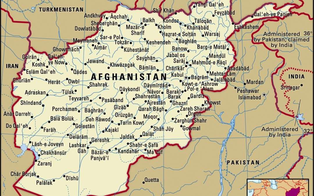
Afghanistan is a landlocked country, meaning it has no sea or ocean access. It is located between Central Asia, South Asia, and the Middle East.
Because of this position, it has always been an important connection point for trade, travel, and cultural exchange.
The capital city is Kabul, which sits in the eastern part of the country and acts as its main political and economic center.
Countries Around Afghanistan
Afghanistan shares borders with six countries:
- Pakistan (east and south)
- Iran (west)
- Turkmenistan (northwest)
- Uzbekistan (north)
- Tajikistan (north)
- China (far northeast through the Wakhan Corridor)
These borders are mostly made of mountains and difficult terrain.
Mountains: The Main Feature of Afghanistan
Most of Afghanistan is covered by mountains. In fact, mountains take up a large part of the country.
The most famous mountain range is the Hindu Kush, which runs through the center of the country.
Important facts:
- The highest mountain is Noshaq (about 7,492 meters)
- Many villages are located in mountain valleys
- Roads and travel are often difficult due to steep land
These mountains also act as natural walls, separating regions from each other.
Lowlands and Plains
Northern Plains
In the north, the land is flatter and more suitable for farming. Many crops are grown here, and it is one of the most productive agricultural areas in the country.
Southern & Western Areas
The south and west are more dry and open. These regions have deserts, rocky land, and wide empty spaces with very low rainfall.
Deserts of Afghanistan
Afghanistan also has large desert regions, especially in the south and southwest.
Registan Desert
- Sandy and dry area
- Has dunes and open sand fields
- Some nomads still use it for seasonal grazing
Dasht-e Margo (Desert of Death)
- One of the harshest areas in the country
- Very dry with little or no vegetation
- Mostly rocky and flat land
- Extremely low population
These deserts show the extreme climate of Afghanistan.
Rivers and Water Sources
Even though Afghanistan is dry, it has important rivers that support life and farming.
Major rivers include:
- Kabul River – flows toward Pakistan
- Amu Darya – forms part of the northern border
- Helmand River – longest river inside the country
- Harirud River – flows near Herat region
Afghanistan also has beautiful lakes such as Band-e Amir, known for its blue natural water and mountain scenery.
Climate and Weather
Afghanistan has a very mixed climate depending on the region.
- Winters are very cold, especially in the mountains
- Summers can be extremely hot in desert areas
- Rainfall is low in most parts of the country
- Spring is the most important season for farming
In simple terms, Afghanistan has strong weather differences cold, hot, dry, and sometimes windy depending on location.
Forest Areas
- Only a small part of the country is forested
- Most forests are in eastern mountain regions
- Many forest areas have been reduced over time
Even with small coverage, these forests are important for wildlife and the environment.
Natural Resources
Afghanistan has many natural resources under its land, including:
- Natural gas
- Coal
- Copper
- Iron
- Gold and precious stones
- Other valuable minerals
These resources are important for the country’s future development.
Summary
Afghanistan is a country of strong contrasts:
- High mountains and deep valleys
- Dry deserts and fertile plains
- Cold winters and very hot summers
Its geography is challenging, but also very beautiful and diverse. This mix of landscapes has shaped Afghanistan into a unique country with a rich natural environment.